
Visit Andorra’s hiking trail maps come with all kinds of useful information – as well as a geographical map, you also get the route’s duration, difficulty rating, elevation gain (gradient), altitude, flora and fauna, the mountain shelters available along the way and a description of each of its stages. There’s also plenty of graphical information! The Andorra Trail Guide is a key publication for beginner and experienced hikers alike, as it contains all the information required to make the most of the Principality’s rich and diverse natural beauty.
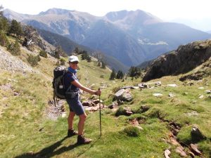
Hiking is just one of Andorra’s vast range of tourism activities – it’s the ideal way to soak up the natural landscape all around you, discover hidden gems and uncover the mysteries deep in the mountains. The Principality offers a wide range of different routes suitable for all kinds of hikers, across Andorra’s three nature parks: the Valley of Sorteny, the Valleys of Comapedrosa and Madriu-Perafita-Claror, the latter being classified as a World Heritage Site by UNESCO in 2004.
The hiking guide features routes for all tastes and experience levels. All paths are clearly marked and signposted thanks to a variety of indications, ranging from painted marks to wooden signposts, and all mark and signpost legends are included in the guide, to help make sense of it all.
The guide, published in English, French, Spanish and Catalan, is available in its printed version, featuring over 60 different routes! The guide can be purchased at Andorra’s Tourist Offices.
Andorra Trail Guide
The Andorra Trail Guide includes routes in all three of Andorra’s nature parks. One of these, the Valley of Sorteny, is an area measuring 1,080 ha (4.2 sq. mi) and is home to chamois, roe deer, marmots, martas and wild boars. Declared a Biosphere Reserve by UNESCO since October 2020, the Valley of Sorteny nature park has a wide variety of flora, with over 700 phanerogam, or seed plant species – over 50 of which are endemic to the Pyrenees! The park organises guided thematic excursions throughout the year – these are known as eco tourist routes – which include birds, butterflies and wetlands, glacial circus countryside and ancient forests.
To reach the park, take the CG-3 road heading towards Ordino Arcalís and turn onto the CS-370 road once you have passed the village of Serrat. The park also features a warden-protected lodge that can be visited in both summer and winter months and includes restaurant services.
Another park whose routes are featured in the Andorra Trail Guide is Comapedrosa, which includes the Pic de Comapedrosa, Andorra’s highest peak at 2,942 m (9,650 ft). This park covers a territory that extends across 15.42 sq. km (6 sq. mi). Its main feature is its imposing high mountain scenery formed by forests, lakes and waterfalls. Because of its extensive network of hiking routes and high mountain huts, a large number of excursions can be organised here, perfect for contemplating the rich flora and fauna typical of the area.
Which trail route should I choose?
The aforementioned eco tourist routes are available at Comapedrosa Nature Park, too. One of these is the guided hiking route Pla d’Estany, a moderately difficult route lasting half a day (4 hours). This is a walk into a deep, wide glacier but its access is not too difficult. At the bottom of the valley are deciduous forests (those that shred their leaves annually), and as the walk ascends, visitors will access Scots pine woods and stumble across woody vegetables such as the hazelnut tree and viburnum. Birds such as the white wagtail, the wren, the robin and the blue tit can be heard here.
Another available eco tourist route available at Comapedrosa is the guided hiking route Tomb al Riu Pollós, categorised as an easy route. This trail goes through Scots pine forests, deciduous woods and other tree species such as the elderberry, the ilex, the goat willow and the aspen. Species such as the blackcap, the common house martin and the blue and coal tits can be seen here. The Riu Pollós is also home to the white-throated dipper and the Pyrenean newt, as well as to roe deer, foxes, beech martens and badgers. This trail leaves on Sundays at 9am, lasts between three and four hours.
To get a first-hand experience of Comapedrosa, we recommend you stop by our visitors’ centre, where you can find out interesting information about this stunning natural park. You can also spend some time trying out our geocaching sports activity, where you will hunt for hidden “treasures” via GPS!
Who can enjoy hiking in Andorra?
Anyone can enjoy hiking in Andorra! There are routes available for all ages and experience levels at all three nature parks, including the Madriu-Perafita-Claror Valley, in the south-east of the Principality of Andorra, occupying an incredible 4,247 ha (16 sq. mi), or 10% of its territory. This valley stretches through the parishes of Andorra la Vella, Escaldes-Engordany, Encamp and Sant Julià de Lòria, with one of the most popular accesses to the valley located on the road to Engolasters. This valley is the most important secondary river basin in the country and is 12 km (7.5 mi) long from end to end.
The valley’s highest peak is Pic de la Portelleta, at 2,905 m (9,530 ft) above sea level. There are many routes available in this nature park, so you can easily contemplate the natural habitat of animal and plant species, some of which are very rare or even in danger of extinction. Whatever route you finally choose, you’ll find old shepherd cabins recently restored in a traditional way, plots of land enclosed by walls that used to contain vegetable gardens, huts and grazing areas for livestock, etc.
This valley also offers you the chance to hike along one of its most appealing trails, the Coronallacs trail, a circular hiking route around 90 km long (55 mi), connecting the four refuges in Andorra. This route will take you about five days to complete and begins at the parish of Escaldes. And if you’d like to try out more activities here, you can do so: horse riding, climbing, hunting, fishing, snowshoeing and mountain skiing are all available.
Passes and tickets
To get to the valley, take the CG-2 road and at the first roundabout turn onto the Carretera d’Engolasters, CS-200. Don’t forget, guided excursions for all nature parks can be booked in advance from May to October. For visitor safety, we recommend going on routes with altitudes of over 1,700 m (5,580 ft) between the end of June and the end of September.
Our online factsheet, available at the following link, has comprehensive information on all the hiking trails available, and the directory can be filtered by location (Canillo, Encamp, Ordino, La Massana, Andorra la Vella, Sant Julià de Lòria and Escaldes-Engordany), by skill level (ranging from Easy to Experts only) and trip time. Each trail in the factsheet can be shared, features a downloadable track map and a helpful altitude graph.
You can of course also obtain information at one of the Principality’s Tourist Offices, such as at La Massana, open from 9am to 1pm and 3pm to 7pm. It’s located in the Plaça de les Fronteres, and is an invaluable resource for planning your visit. In winter you’ll be able to receive assistance in purchasing ski passes and renting snow-related equipment, as well as explanatory material on the Vallnord-Pal Arinsal ski resort, one of several ski resorts in the area.