
Its hiking trail maps are packed with all kinds of useful information. Every fact sheet contains detailed information on Andorra’s main hiking routes: a map, the route’s duration, difficulty, elevation gain, altitude, fauna, flora, the mountain shelters along the route and a description of each of its stages. They also have plenty of graphical information.
The Andorra Trail Guide is an essential publication for hikers, who will have all the information they need to discover the Principality’s natural beauty and diversity.
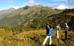
Andorra offers a vast range of tourism activities. Hiking is just one of them. It gives you the opportunity to soak up the natural landscape around you, discover amazing spots and places and uncover the mysteries of its mountains. There are routes throughout the entire Principality, and plenty of different options, as Andorra boasts 3 nature parks: The Valley of Sorteny, the Valleys of Comapedrosa and Madriu-Perafita-Claror. The latter was classified as a World Heritage Site by UNESCO in 2004.
In this hiking guide you’ll find routes for every taste: varying difficulty levels, distances and durations. All paths are duly marked thanks to a variety of indications, ranging from painted marks to wooden signposts. All mark legends are included in the guide.
You can buy the printed version of Andorra’s Trails hiking guide, which contains more than 60 different routes, at Andorra’s Tourist Offices, for as little as €6. (Guide published in ENG, FR, ES and CAT).